Every modality, annotated to precision.
From pixel-perfect image masks to frame-accurate video tracking and geospatial intelligence — domain-expert annotation across image, video, and GIS, delivered with zero-trust security and a validation-led engagement model.
Image Annotation
5 TYPESSegmentation
Image segmentation enables businesses to extract meaningful insights from visual data by identifying and isolating specific objects within images. This technology is widely used in industries like mobility, retail for inventory management, in agriculture for crop monitoring, and in healthcare for diagnostic imaging. By leveraging image segmentation, companies can automate processes, reduce human error, and enhance decision-making capabilities, ultimately driving efficiency and improving outcomes across various sectors.
Image segmentation is essential in numerous real-world applications. In autonomous vehicles, it helps identify roads, pedestrians, and obstacles. In medical imaging, it aids in detecting tumors or organ boundaries. E-commerce platforms use it to enhance visual search and recommend similar products. Additionally, in smart farming, segmentation assists in assessing plant health and detecting weeds. These diverse use cases highlight how segmentation enhances precision and functionality in both everyday and specialized tasks.
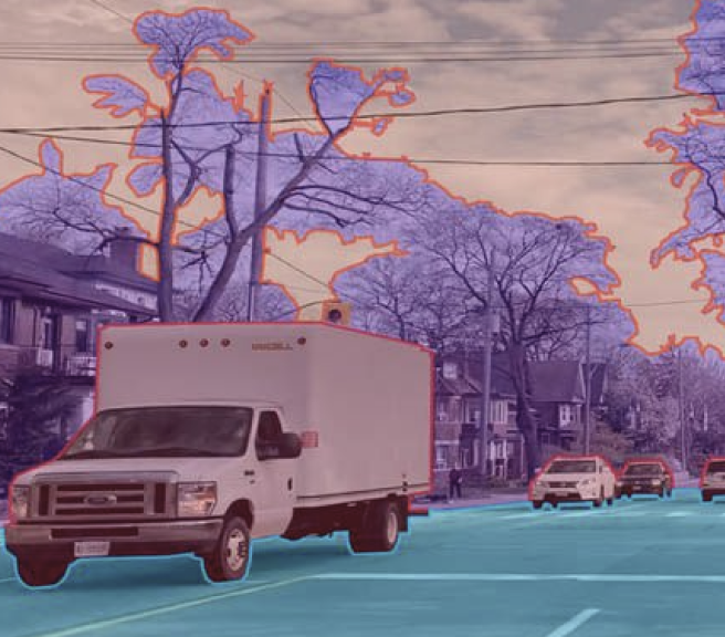 Real output · segmentation
Bounding Box
Bounding box annotation plays a crucial role in training AI models for object detection across various industries. In retail, it powers smart checkout systems and shelf monitoring. In logistics, it supports automated package tracking and sorting. By labeling objects within images accurately, businesses can enhance machine vision capabilities, streamline operations, and reduce manual intervention. Bounding box annotation forms the foundation for systems that require precise object localization and real-time analysis.
Bounding boxes are widely used in real-world applications like surveillance systems to detect intruders, in autonomous vehicles to identify pedestrians and traffic signs, and in warehouse robotics for item recognition and sorting. E-commerce platforms utilize them for tagging and categorizing products in images. They're also vital in agriculture, helping detect and track livestock or monitor equipment. This type of annotation is essential for any application where identifying the position and size of objects is key.
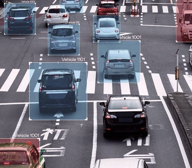 Real output · bounding box
Polygon
Polygon annotation is essential for businesses that require high-precision object recognition, especially for irregularly shaped items. It's widely used in industries like agriculture for mapping crop areas, in retail for shelf analysis, and in insurance for damage assessment. By outlining the exact shape of objects, polygon annotation allows machine learning models to better understand complex scenes, resulting in more accurate analytics, enhanced automation, and improved decision-making across a range of business processes.
Polygon annotation excels in scenarios requiring detailed shape recognition. In autonomous driving, it defines the precise contours of road elements, vehicles, and pedestrians. In medical imaging, it enables accurate segmentation of tumors or organs. Drones use it to monitor landscapes or construction sites, while fashion e-commerce platforms apply it for outlining clothing items. This level of precision supports more refined machine learning outputs, especially in environments where object boundaries are complex and irregular.
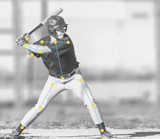 Real output · polygon
Keypoint
Keypoint annotation is critical for businesses that rely on detailed motion tracking and pose estimation. It is commonly used in sectors like fitness tech for form correction, entertainment for motion capture, and healthcare for physical therapy analysis. By marking specific points on objects or the human body—such as joints or facial landmarks—companies can develop AI systems that understand subtle movements, improve user interaction, and enhance performance monitoring or safety mechanisms.
Keypoint annotation is widely used to track human poses in sports analytics, enabling performance optimization and injury prevention. In augmented reality (AR), it allows for real-time facial tracking and expression mapping. It's also employed in robotics for gesture recognition, and in driver monitoring systems to detect fatigue or distraction. These use cases demonstrate its value in applications where identifying precise positions and movements of body parts or components is essential for intelligent response.
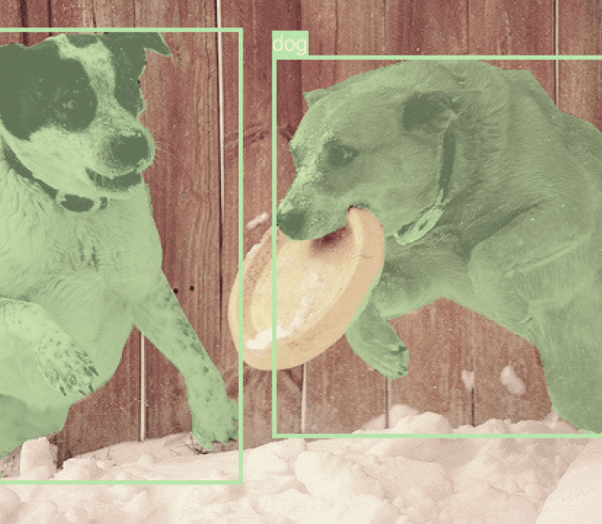 Real output · keypoint
Image Classification
Image classification is a powerful tool for businesses aiming to automate visual content analysis. It enables rapid sorting, tagging, and organization of large image datasets. Industries like e-commerce use it for product categorization, healthcare for disease detection in scans, and agriculture for identifying plant species or conditions. By training models to recognize and classify images, companies can streamline workflows, improve data accuracy, and enhance user experiences through intelligent visual recognition systems.
Image classification is used in various domains such as social media platforms for detecting inappropriate content, in manufacturing for identifying defects on production lines, and in wildlife conservation for recognizing animal species in camera trap images. It also supports smartphone apps in identifying food items, plants, or landmarks. These use cases highlight how classification helps systems interpret images quickly and accurately, driving smarter automation and decision-making in everyday and specialized applications.
Video Annotation
8 TYPESBounding Box Annotation
Identifies objects by placing rectangular boxes around them, useful for object detection and localization tasks (e.g., vehicles, pedestrians).
Bounding box annotation in video enables businesses to track and analyze objects frame-by-frame with precision. It is crucial in industries like security for surveillance monitoring, automotive for autonomous vehicle navigation, and retail for customer behavior analysis. By continuously tracking objects across time, businesses gain insights into movement patterns and interactions. This data fuels advanced machine learning models that support automation, real-time decision-making, and improved safety in dynamic, video-based environments.
Video bounding box annotation is used in traffic management systems to monitor vehicle flow and detect violations. In sports, it helps track players and the ball for performance analytics. Surveillance systems use it to detect suspicious behavior or unauthorized access. It's also applied in warehouse automation for tracking goods and machinery. These use cases highlight its value in understanding real-time movement, enabling predictive analytics, and enhancing situational awareness in complex, time-based scenarios.
Polygon Annotation
Outlines irregularly shaped objects precisely, beneficial for capturing accurate object boundaries in complex visual environments.
Polygon annotation in video provides detailed object tracking by outlining complex shapes across frames. This is especially valuable for industries like autonomous driving, where precise object boundaries are critical for safe navigation, or in construction and mining, where tracking irregular machinery is necessary. Businesses use polygon annotation to improve model accuracy in dynamic environments, enabling smarter automation, enhanced object recognition, and better decision-making through highly detailed visual analysis over time.
Polygon annotation is used in self-driving car development to accurately detect and track pedestrians, vehicles, and road signs with irregular shapes. In sports broadcasting, it enables precise player and equipment tracking for advanced analytics. It's also applied in drone surveillance for monitoring large and complex structures, like buildings or farmlands. These use cases demonstrate how polygon annotation enhances machine perception in videos where high granularity and object precision are essential.
Semantic Segmentation
Classifies every pixel in a frame into predefined categories (e.g., background, objects), useful for fine-grained scene understanding.
Semantic segmentation in video annotation enables businesses to analyze scenes at the pixel level, allowing for highly accurate object and environment understanding. It is widely used in industries like automotive for autonomous driving, smart cities for traffic and pedestrian monitoring, and agriculture for crop and soil analysis. By classifying each pixel across video frames, companies can build robust AI models that respond intelligently to complex visual inputs, improving safety, efficiency, and automation capabilities.
Semantic segmentation is used in autonomous vehicles to distinguish roads, sidewalks, pedestrians, and vehicles in real-time video streams. In healthcare, it assists in analyzing endoscopy or surgery videos by identifying tissues and instruments. Smart city systems use it to monitor public spaces and manage traffic flows. It also supports environmental monitoring through drone footage analysis. These use cases show how pixel-level video analysis enables smarter, context-aware systems across various high-impact applications.
Instance Segmentation
Identifies individual objects at a pixel-level, differentiating multiple instances of the same class in a frame (e.g., distinguishing multiple people in a crowd).
Instance segmentation in video annotation allows businesses to identify and track individual objects, even when they overlap or interact. It is crucial for industries like autonomous driving, where distinguishing between individual pedestrians, vehicles, and other objects is vital for safety. In retail, it helps track multiple products in a single video frame, enabling better inventory management and automated checkout systems. By providing precise object-level identification, instance segmentation enhances automation and decision-making processes in dynamic environments.
Instance segmentation is applied in autonomous vehicles to detect and differentiate individual objects, such as pedestrians and other cars, in real-time traffic videos. In sports analytics, it helps track players and equipment, even in crowded scenarios. In medical imaging, instance segmentation aids in isolating and analyzing individual cells or organs for disease diagnosis. It's also used in industrial environments for monitoring multiple machines or tools in video feeds, ensuring efficient operation and safety. These use cases show its power in real-time, object-level analysis.
Keypoint Annotation
Marks important points on objects, often used in human pose estimation, facial recognition, and gesture analysis.
3D Cuboid Annotation
Defines objects using 3D bounding boxes, helpful in autonomous driving, robotics, and drone navigation systems.
3D cuboid annotation in video allows businesses to detect and track objects in three-dimensional space, providing a more accurate representation of the physical world. It's used in industries like autonomous driving, where understanding the spatial relationship between objects is crucial for navigation and collision avoidance. In logistics and warehousing, it helps with tracking the position and movement of 3D objects like packages or equipment, supporting improved automation, real-time tracking, and operational efficiency.
3D cuboid annotation is essential for autonomous vehicles, helping them understand the position and dimensions of objects like other vehicles and pedestrians in a 3D environment. In manufacturing, it supports robot navigation by accurately mapping the locations of machinery and parts. It's also used in construction for tracking the dimensions and movement of large equipment or materials. Additionally, in retail, it can be applied for visualizing product placement in three-dimensional shelf layouts for optimized inventory management.
Polyline Annotation
Draws continuous lines to represent linear objects such as roads, lanes, or boundaries, beneficial for navigation and autonomous driving scenarios.
Polyline annotation in video is used to outline the path or trajectory of moving objects, providing critical data for industries like transportation and robotics. In autonomous driving, it helps track road lanes, traffic flow, and vehicle paths. In sports analytics, it can be used to track player movements or ball trajectories. By capturing movement patterns with high accuracy, polyline annotation supports more precise AI models for navigation, performance analysis, and real-time decision-making.
Polyline annotation is commonly applied in autonomous vehicles to track and predict the movement of traffic, road lanes, and obstacles. In sports, it is used to trace the path of the ball or players, providing insights into performance and strategy. In robotics, polyline annotations assist in guiding robot movements along predefined paths. Additionally, it's used in video surveillance to track intruders or monitor specific routes within a defined area, enhancing security operations.
Event/Temporal Annotation
Marks start and end timestamps of events or actions within videos, essential for activity recognition and behavior analysis.
Event/temporal annotation in video involves labeling specific events or actions that occur over time, allowing businesses to track and analyze dynamic processes. In sectors like security, it helps identify unusual behaviors or specific incidents within surveillance footage. In sports, it's used to annotate key moments like goals, fouls, or player actions. By understanding events in the temporal context, businesses can automate analysis, improve decision-making, and enhance monitoring systems across various industries.
Event/temporal annotation is crucial for detecting specific actions in videos, such as in sports where key events like goals or penalties are marked for analysis. In security surveillance, it helps pinpoint security breaches, suspicious activities, or alarms. In healthcare, it can identify critical moments in medical procedures or patient movements. It's also used in behavior analysis, helping businesses track customer actions or interactions in video data, improving customer insights and marketing strategies.
These annotation types help create comprehensive, accurate, and robust training datasets suitable for diverse AI and machine learning applications.
GIS
2 TYPESStandard Annotation
Standard GIS annotation involves labelling basic geographical features like roads, rivers, or landmarks within spatial data. It's commonly used in urban planning, environmental monitoring, and navigation systems. By tagging features with clear, consistent labels, businesses can create more accurate maps, improve asset management, and support planning decisions. It enables industries to visualize and manage geographical data efficiently, fostering better decision-making, disaster management, and resource allocation.
Standard GIS annotation is used in city planning to mark streets, utilities, and important infrastructure. It aids in environmental monitoring by tagging bodies of water, forests, and conservation areas for easier tracking. In navigation, it helps in labeling roads, intersections, and points of interest for better route planning. Real estate companies use it to annotate land parcels and zoning areas for property assessments. These examples show how basic feature identification supports better geographical insights.
Feature-Linked Annotation
Feature-linked GIS annotation connects geographical data with additional attributes, allowing businesses to gain deeper insights into spatial relationships. This is crucial in fields like agriculture for mapping soil types, in transportation for tracking infrastructure health, and in utilities for managing power grids. By linking geographic features with detailed metadata, businesses can perform advanced analysis, optimize resource use, and implement more targeted solutions for urban development, environmental protection, and disaster response.
Feature-linked GIS annotation is used in agriculture for annotating crop fields with data on soil type, moisture levels, and irrigation patterns to improve yield prediction. In transportation, it helps annotate road segments with traffic patterns, accident hotspots, and maintenance schedules to enhance infrastructure management. Utilities companies use it to track power lines with data on grid health, service interruptions, and maintenance needs. These use cases show the power of linking spatial data with actionable attributes to support smarter decision-making.
Not sure which annotation type fits? Send us a sample.
Free POC · no contract required · validate before you buy
Start Free POC